 29+Years
29+Years
29+Years


Special Order
Ships in 1-2 weeks
Condition: New

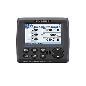
Furuno SC70 Satellite Compass
Model: SC70The SC70 is the latest satellite compass built on FURUNO’s commercial-grade technology platform. These satellite compasses prove their value by increasing the accuracy of other devices, such as Radar, ARPA, Scanning Sonar, Current Indicator, Chart Plotter, ECDIS and Autopilots. They provide a highly accurate heading input to these other technologies by utilizing the very latest GNSS (Global Navigation Satellite System). This satellite system is comprised of GPS, Galileo and GLONASS to ensure the highest precision and a continuous coverage.
The SC70 provides a variety of data, including GPS Positioning, SOG (Speed Over Ground), COG (Course Over Ground), ROT (Rate Of Turn) and 3-axis speed (bow, stern and longitudinal). All of these data assist with critical maneuvers, such as berthing. The compasses is maintenance free - a great asset for any vessel.
The Furuno SC70 Satellite Compass is a maritime navigation device designed for small to medium vessels requiring precise heading and positioning data. This system provides a highly accurate heading of 0.4 degrees, essential for the optimal performance of integrated systems such as autopilots, radar, ARPA, scanning sonar, chart plotters, and ECDIS. It utilizes multiple Global Navigation Satellite Systems (GNSS), including GPS, Galileo, and GLONASS, to ensure continuous coverage and high precision, mitigating issues related to satellite availability. Beyond heading, the SC70 delivers critical data points like Speed Over Ground (SOG), Course Over Ground (COG), Rate Of Turn (ROT), and 3-axis speed (bow, stern, and longitudinal), which are valuable for navigation and berthing maneuvers. The unit is IMO Type-approved as THD, GPS, and ROTI, complying with IEC and ISO requirements, and offers easy integration into existing shipboard networks via Ethernet. It features a rapid follow-up rate of 40 degrees/s and is maintenance-free with no recurring costs due to its lack of mechanical parts. Starting time is approximately 90 seconds from power-on.


The SC70 can integrate with and provide highly accurate heading data for autopilots, Radar, ARPA, Scanning Sonar, Current Indicators, Chart Plotters, and ECDIS. It easily integrates into existing shipboard networks via Ethernet.
The product includes three main components: Box 1 contains the SC701 Junction Box, Box 2 contains the SC702 Display, and Box 3 contains the SC703 Antenna Unit.
The SC70 utilizes multiple Global Navigation Satellite Systems (GNSS), including GPS, Galileo, and GLONASS, to ensure high precision and continuous coverage. It is also SBAS compatible (EGNOS, WAAS, MSAS).
Yes, the SC70 can be easily retrofitted by using existing antenna cabling from SC-50/55/60/110/120 models. The LAN_CNV option kit is necessary for this process.
SC70 - Furuno Satellite Compass with 4.3" LCD and 2 Antennas





























































