 29+Years
29+Years
29+Years


6 Available / 1 Sold
Condition: New

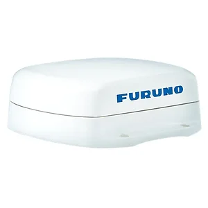
Furuno SCX20 Compact Dome Satellite Compass, NMEA2000® Certified
Model: SCX20Utilizing four separate GNSS Antennas for the ultimate in responsiveness, the SCX20 and SCX21 set a new standard for reliable and accurate heading for all of your marine electronics. Traditionally, a Satellite Compass™ calculates heading using one baseline between two antennas; the SCX20/21’s four antennas can calculate heading information using any one of the six baselines drawn between the four antennas.
The unprecedented quad-antenna design of the SCX20 and SCX21 makes them capable of calculating extremely accurate heading, pitch, roll, and heave information. They are the perfect heading solution for complex vessel installations where the view of satellites may sometimes be obstructed.
The SCX20 and SCX21 enhance the performance of on-board equipment such as Radar, Fish Finders, Sonar, and Autopilots. Accurate heading information empowers your NAVpilot to keep a better course, saving time, fuel, and money on every voyage; meanwhile, precise pitch, roll, and heave information stabilizes the display for many Furuno Fish Finders and Sonars, allowing for an accurate presentation even in the roughest of seas.
Full NMEA2000 Certification provides plug and play connectivity to any NMEA2000 network. Distribute high-accuracy navigation data as well as air temperature and barometric pressure. Initial Setup and configuration can be done from any Navnet TZT2/TZT3 MFD, Navpilot 300, or use the free Furuno SC Setting Tool PC Software when properly interfaced.
When connected to Furuno SCX20/21, the Radar’s echo trails hold steady and clearly depict an accurate echo trail thanks to the SCX20/21’s amazing accuracy. Company A’s satellite compass fails to uphold a steady heading, making echo trails virtually unintelligible. Company B’s heading accuracy fluctuates by +/- 3¯ with a slower update, causing an echo trail that has a wide zig-zag pattern. Company C’s heading accuracy fluctuates by +/- 5° with a faster update, causing an echo trail that is indistinguishable and confusing.
Specifications| Data Type | NMEA2000 |
| Power Usage | 12-24 VDC |
| Display Type | N/A |
| Receiver Type | GPS or GLONASS or Galileo or QZSS or SBAS |
The Furuno SCX20 Satellite Compass is designed for marine navigation and integrates with existing NMEA2000 networks. This compact dome satellite compass utilizes a quad-antenna GNSS design to provide heading, pitch, roll, and heave data. Unlike traditional two-antenna systems, the SCX20 calculates heading using multiple baselines between its four antennas, enhancing reliability, particularly in complex installations where satellite visibility may be intermittently obstructed. It is suitable for vessels requiring stable and accurate navigation data for onboard equipment such as Radar, Fish Finders, Sonar, and Autopilots. The system's precise data output can contribute to maintaining a consistent course with autopilots and stabilizing sonar/fish finder displays in varying sea conditions. Connectivity is facilitated via NMEA2000 certification, allowing for plug-and-play integration and distribution of navigation, air temperature, and barometric pressure data. Initial setup can be performed using Furuno MFDs, Navpilot 300, or PC software.
The Furuno SCX20 outputs NMEA2000 data, including high-accuracy navigation data, air temperature, and barometric pressure.
The box includes the SCX20 Compass, a cable assembly (FRU-NMEA-PMMFF-06), mounting hardware (screws, gaskets, fixtures), ThreeBond Adhesive, a flush mount template, a roof mount installation notice, and an operator's manual.
The quad-antenna design allows the SCX20 to calculate heading, pitch, roll, and heave information with high accuracy. This enhances the performance of equipment like Radar by providing steady echo trails, and stabilizes Fish Finder and Sonar displays for accurate presentations even in rough seas.
The Furuno SCX20 operates on a 12-24 VDC power supply.
SCX20 - Furuno Satellite Compass NMEA2000 Output





























































