 29+Years
29+Years
29+Years
2 Available
Condition: New

Navionics+ Brazil - Detailed Marine Cartography
Experience the world's leading solution in marine mapping with state-of-the-art Navionics+ cartography for your compatible chartplotter. This comprehensive package is ideal for both offshore and inland waters, including a wealth of detail-rich integrated mapping options covering coastal regions, lakes, rivers, and beyond.
With SonarChart™ 1’ (0.5 meters) HD bathymetry maps, you'll access advanced features such as dock-to-dock route guidance technology, live mapping, and Plotter Sync, allowing for seamless, wireless access to daily updates and essential navigation tools.
The Navionics Chart Installer software guarantees you’ll always have the freshest chart data available. With dock-to-dock route guidance, receive suggested paths through channels, inlets, and marina entrances. Utilize multiple shading options to aid in shallow-water navigation and identify the best spots for fishing.
Coverage Area:
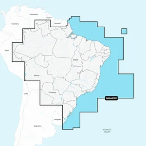
The Navionics+ Brazil - Detailed Marine Cartography, part number 010-C1461-30, provides comprehensive marine mapping for compatible chartplotters. This solution is designed for users navigating both offshore and inland waters within Brazil, specifically covering the Brazilian coast and the Amazon River from Benjamin Constant to the Atlantic Ocean. It integrates detailed mapping of coastal regions, lakes, and rivers, including access to over 44,000 lakes. Key features include SonarChart� 1� (0.5 meters) HD bathymetry maps, which support advanced navigation tools such as dock-to-dock route guidance technology. The system also offers live mapping capabilities and Plotter Sync for wireless access to daily updates. Users can customize map views with advanced options and benefit from community edits, ensuring up-to-date and detailed navigational data for planning and executing marine routes.


010-C1461-30 - Navionics + Brazil - Detailed Marine Cartography





























































