 29+Years
29+Years
29+Years
1 Available
Condition: New

Navionics Platinum+ Chart for Brazil - NPSA012R
The world's leading choice in marine mapping provides the most up-to-date Navionics+ cartography for your chartplotter. This comprehensive solution covers offshore and inland waters, delivering detail-rich integrated mapping for coastal waters, lakes, rivers, and more.
Benefit from SonarChart™ with 1' HD bathymetry maps, while utilizing advanced features like dock-to-dock route guidance, live mapping, and Plotter Sync for seamless updates. Regular use of the Navionics Chart Installer ensures that you have the freshest chart data available.
Your journey will be enhanced by dock-to-dock route guidance, which suggests the optimal path through channels and marina entrances. Additionally, enjoy a variety of shading options for shallow-water navigation, helping you pinpoint the best fishing locations.
Navionics Platinum+ charts integrate everything from Navionics®+ cartography, including coverage of 42,000+ lakes, relief shading, satellite imagery with overlay options, 3D perspectives, and aerial photography.
Coverage Area:
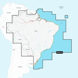
Extensive coverage of the coast of Brazil, including the Amazon River from Benjamin Constant to the Atlantic Ocean.
The Navionics Platinum+ Chart for Brazil, part number 010-C1461-40, is a maritime navigational chart designed for chartplotters. This solution provides integrated mapping for coastal waters, lakes, and rivers across Brazil, including the Amazon River from Benjamin Constant to the Atlantic Ocean. It is suitable for professional marine operators, commercial fishing vessels, and recreational boaters requiring detailed and current cartography for navigation in this region. The chart offers access to over 44,000 nautical charts and includes features such as SonarChart� with 1' HD bathymetry maps, dock-to-dock route guidance, and live mapping capabilities. Users can benefit from Plotter Sync for seamless updates and transfer of routes and markers, ensuring access to the freshest chart data. High-resolution relief shading, satellite imagery, and 3D perspectives are also integrated to enhance situational awareness and aid in route planning.


010-C1461-40 - Navionics Platinum+ Chart for Brazil - NPSA012R





























































