 29+Years
29+Years
29+Years
35 Available
Condition: New

NAUS001L Marine Mapping MicroSD Card
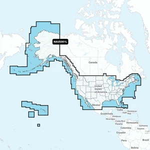
Experience comprehensive mapping of U.S. coasts, lakes, rivers, and inland waterways, along with coverage for Alaska, Hawaii, and parts of Canada such as coastal British Columbia and the Great Lakes. This microSD card also includes areas like Bermuda, the Bahamas, and Baja California, providing extensive navigation support.
With the latest Navionics®+ cartography, you’ll enjoy precise details for both offshore and inland waters. Access features like SonarChart™ 1’ (0.5 meters) HD bathymetry maps, advanced dock-to-dock route guidance, live mapping, and Plotter Sync for wireless updates. The Navionics® Chart Installer ensures that your chart data stays up to date, giving you confidence whether you’re navigating through channels or fishing in your favorite spot.
Features:
The Navionics+ NAUS001L Marine Mapping MicroSD Card, part number 010-C1366-30, provides comprehensive marine cartography for IT and business operations requiring detailed navigation support. This product is designed for integration into compatible marine systems, offering extensive coverage across U.S. coasts, lakes, rivers, and inland waterways, including Alaska, Hawaii, and portions of Canada such as coastal British Columbia and the Great Lakes. Additional coverage extends to Bermuda, the Bahamas, and Baja California. It includes Navionics+ cartography with features like SonarChart 1� (0.5 meters) HD bathymetry maps, advanced dock-to-dock route guidance, and live mapping capabilities. The included Navionics Chart Installer and Plotter Sync feature facilitate daily chart updates, ensuring current data for navigation and operational planning. This solution addresses the need for precise, up-to-date marine mapping in various operational environments.


010-C1366-30 - Navionics + NAUS001L Marine Mapping MicroSD Card





























































