Navionics+ Central America & Caribbean
Experience the premier choice in marine mapping with Navionics+, featuring the latest cartography tailored for your compatible chartplotter.
This comprehensive solution covers both offshore and inland waters, providing detailed mapping of coastal areas, lakes, and rivers. Enhance your navigation with SonarChart™ HD bathymetry maps, offering 1' (0.5 meters) accuracy, and utilize advanced features like dock-to-dock route guidance, live mapping, and Plotter Sync for seamless wireless updates.
The Navionics Chart Installer tool keeps your charts fresh and updated. With dock-to-dock route guidance, navigate effortlessly through channels and marinas. Multiple shading options aid in shallow-water navigation, highlighting optimal fishing spots.
Chart Code: NASA010R
Coverage Area:
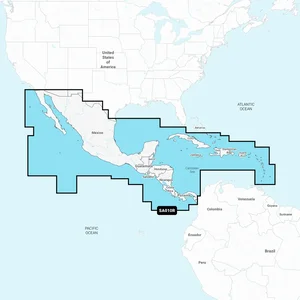
Comprehensive coverage spans from the west coast of Mexico (Tijuana to Panama, including the full Panama Canal) to the east coast (Panama to Brownsville, TX), and extends throughout the Caribbean covering the Far Bahamas, Turks & Caicos, Cuba, Jamaica, the Cayman Islands, Haiti, the Dominican Republic, Puerto Rico, and the Lesser Antilles to Grenada.
The Navionics+ Central America & Caribbean chart, part number 010-C1459-30, provides detailed marine mapping for compatible chartplotters. This solution is designed for boaters operating in coastal and inland waters across a broad region. It covers the west coast of Mexico from Tijuana to Panama, the full Panama Canal, and the east coast from Panama to Brownsville, TX. Coverage also extends throughout the Caribbean, including the Far Bahamas, Turks & Caicos, Cuba, Jamaica, the Cayman Islands, Haiti, the Dominican Republic, Puerto Rico, and the Lesser Antilles to Grenada. The chart includes access to over 44,000 inland lakes and features SonarChart HD bathymetry with 1' (0.5 meters) accuracy. Users can benefit from dock-to-dock route guidance, live mapping, and Plotter Sync for wireless updates, ensuring current cartography via the Navionics Chart Installer tool. Multiple shading options are available to assist with shallow-water navigation.
This chart provides comprehensive coverage from the west coast of Mexico (Tijuana to Panama, including the full Panama Canal) to the east coast (Panama to Brownsville, TX). It also extends throughout the Caribbean, covering the Far Bahamas, Turks & Caicos, Cuba, Jamaica, the Cayman Islands, Haiti, the Dominican Republic, Puerto Rico, and the Lesser Antilles to Grenada.
Key features include SonarChart HD bathymetry with 1' (0.5 meters) accuracy, dock-to-dock route guidance, live mapping, and Plotter Sync for wireless updates. It also offers access to over 44,000 inland lakes and customizable advanced map options.

Users can receive up to 5,000 daily chart updates for accuracy. The Navionics Chart Installer tool helps keep charts fresh and updated.


Yes, this comprehensive solution covers both offshore and inland waters, providing detailed mapping of coastal areas, lakes, and rivers, with access to over 44,000 inland lakes.
010-C1459-30 - Navionics + Central America & Caribbean - Chart for Boaters