 29+Years
29+Years
29+Years
21 Available
Condition: New

NAUS005R U.S. North - MicroSD Card
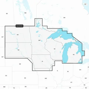
Detailed coverage of the lakes and rivers of Iowa, Michigan, Minnesota, North Dakota, South Dakota, Wisconsin, and the U.S. waters of the Great Lakes that border those states.
Get the world’s No. 1 choice in marine mapping — with the best, most up-to-date Navionics®+ cartography on your compatible chartplotter. For offshore or inland waters, this all-in-one solution offers detail-rich integrated mapping of coastal waters, lakes, rivers, and more. Get SonarChart™ 1’ (0.5 meters) HD bathymetry maps, advanced features such as dock-to-dock route guidance technology (depending on chartplotter model), live mapping, and Plotter Sync to provide wireless access to daily updates. The Navionics® Chart Installer software also ensures the freshest chart data every time out. Navionics route guidance solutions give you a suggested dock-to-dock path to follow through channels, inlets, marina entrances, and more. (Route guidance is for planning purposes only and does not replace safe navigation operations.) Multiple shading options aid in shallow water navigation and make it easy to highlight a target depth range for the best fishing spots.
Features:
**NOT FOR USE IN GARMIN CHARTPLOTTERS**
The Navionics+ NAUS005R U.S. North is a marine mapping solution provided on a microSD card, part number 010-C1368-30. It offers detailed cartography for the lakes and rivers of Iowa, Michigan, Minnesota, North Dakota, South Dakota, Wisconsin, and the U.S. Great Lakes waters bordering these states. This product is designed for business and IT buyers managing fleets or marine operations requiring precise navigational data for compatible chartplotters. It integrates detailed mapping of coastal waters, lakes, and rivers, addressing the need for up-to-date and comprehensive marine charts. Key features include SonarChart 1� (0.5 meter) HD bathymetry maps for detailed bottom structure, and advanced functionalities like dock-to-dock route guidance technology, which suggests paths based on boat settings and chart data. Users can access daily chart updates via the Navionics Chart Installer software or wirelessly through Plotter Sync with the Navionics Boating app. Multiple shading options are available to assist with shallow water navigation and highlight specific depth ranges for fishing. This solution provides integrated Garmin and Navionics content, but it is important to note that it is not for use in Garmin chartplotters.


010-C1368-30 - Navionics + NAUS005R U.S. North





























































