 29+Years
29+Years
29+Years


4 Available
Condition: New

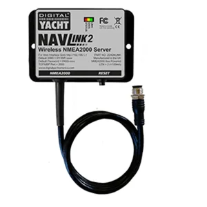
NavLink 2 NMEA to WiFi Gateway
Digital Yacht's NMEA to WiFi adapter.
NavLink:
NavLink is a low cost app designed for use with an iPhone or iPad. It transforms your iPad into a full function chart plotter with detailed electronic charts and an overlay of your boat’s position, track and heading. It’s purchased through the Apple app store and includes detailed Admiralty UKHO charts covering the whole of the UK & Eire. Additional USA (S57 NOAA), French, Benelux, German and Danish charts can be added via an In-App Purchase. The NOAA S57 charts cover the whole of the US.
Charts can be presented north up or course up and routes and waypoints are created and edited using a simple touch screen interface. Real time navigation shows your current position, track, course, speed, ETA, VMG, bearing and distance to next waypoint. There’s a simple A-B chart ruler too and you can tap on an object such as a buoy or nav-aid and get a pop up data window of its characteristics. Current weather data and local conditions can be downloaded from weather buoys (internet connection required) which is great for last minute local weather before setting off on a voyage. The S57 Admiralty UKHO charts are vector based so data can be layered and enabled / disabled by the user allowing charts to be de-cluttered as appropriate.
It’s also designed to work seamlessly with Digital Yacht’s NMEA to WiFi devices so will integrate with your boat’s GPS and AIS systems. If AIS data is available, you’ll see AIS targets overlaid with all their identity information and a heading line as well as alarms for CPA and TCPA.
Utilizing your on board GPS with these wireless servers means you don’t need a GPS enabled iPad. Even if your device is GPS enabled, it significantly reduces battery drain when using an external source. It also means your iPad/Phone can be used below deck and generally, the boat’s GPS is superior for marine based navigation.
NavLink also helps with your watch keeping and lookouts. In HorizonView mode, you can use the camera on the iPhone/iPad to scan the horizon. You’ll get an overlay on the camera screen of nav-aids, AIS targets and waypoints which serves as a great visualization aid.
Features:
The Digital Yacht NavLink 2 NMEA to WiFi Gateway, part number ZDIGNLINK, is an NMEA to WiFi adapter designed for marine navigation. This device facilitates the integration of a boat's NMEA data with an iPhone or iPad, enabling these mobile devices to function as a chart plotter. It is suitable for marine professionals and boat owners who require real-time navigation data, including position, track, course, and speed, displayed on a portable device. The gateway allows for the overlay of AIS targets and navigational aids when connected to compatible systems, enhancing situational awareness. By utilizing the boat's onboard GPS, it reduces battery drain on the mobile device and provides a potentially more reliable GPS signal for marine environments. This solution addresses the need for a flexible and portable navigation display that leverages existing NMEA data streams.
NavLink 2 NMEA to WiFi Gateway
Digital Yacht's NMEA to WiFi adapter.
NavLink:
NavLink is a low cost app designed for use with an iPhone or iPad. It transforms your iPad into a full function chart plotter with detailed electronic charts and an overlay of your boat’s position, track and heading.It’s purchased through the Apple app store and includes detailed Admiralty UKHO charts covering the whole of the UK & Eire. Additional USA (S57 NOAA), French, Benelux, German and Danish charts can be added via an In-App Purchase.The NOAA S57 charts cover the whole of the US.
Charts can be presented north up or course up and routes and waypoints are created and edited using a simple touch screen interface. Real time navigation shows your current position, track, course, speed, ETA, VMG, bearing and distance to next waypoint. There’s a simple A-B chart ruler too and you can tap on an object such as a buoy or nav-aid and get a pop up data win
The NavLink 2 NMEA to WiFi Gateway is designed to work with iPhones and iPads. It supports Digital Yacht WLN10, iNavHub, NavLink, and iAIS products, allowing NMEA data to be utilized on these Apple devices.
The product data specifies the NavLink 2 NMEA to WiFi Gateway as an adapter. The NavLink app, which transforms an iPad or iPhone into a chart plotter, is a separate low-cost purchase through the Apple App Store.
The NavLink app includes detailed Admiralty UKHO charts for the UK & Eire. Additional charts for the USA (S57 NOAA), French, Benelux, German, and Danish regions can be added via an in-app purchase.
No, the NavLink 2 NMEA to WiFi Gateway allows you to utilize your boat's onboard GPS, meaning a GPS-enabled iPad or iPhone is not required. This also helps reduce battery drain on the mobile device.
ZDIGNLINK - Digital Yacht NavLink 2 NMEA to WiFi Gateway





























































