 29+Years
29+Years
29+Years
Special Order
Ships in 1-2 weeks
Condition: New

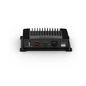
Garmin GLS10 Sonar Module
Model: 010-12954-00The easy-to-install, networkable GLS 10 sonar black box allows you to see live, real-time scanning sonar. Add the LVS32 transducer model to see easy-to-interpret live scanning sonar images of structure, bait and fish swimming below and around your boat. And you can share sonar images seamlessly across multiple networked chartplotters.
Requires LVS32, not included
Specifications| 9.6 in x 5.9 in x 2.6 in (24.5 x 14.9 x 6.5 cm) | |
| Weight | 4.3 lbs (2.0 kg) |
| Water rating | IPX7 |
| Garmin Marine NetworkTM ports | 1 (small connector) |
| Temperature range | Operating: -15 C to 70 C |
| Sonar Features & Specifications | |
| Frequencies supported | 530 - 1,100 kHz |
| Transmit power | 500 W |
| Maximum depth | Down and Forward: 200 feet (61.0 m) |
| Electrical | |
| Power input | 10-32 V |
| Power usage | 21 W typical, 58 W max |
| Fuse | 7.5 A |
The Garmin GLS10 Sonar Module, part number 010-12954-00, is a networkable black box designed for real-time scanning sonar capabilities. This module is intended for IT and marine professionals or businesses requiring advanced fishfinding technology for their vessels. It provides live, easy-to-interpret sonar images of underwater structure, bait, and fish. To function, it requires the addition of an LVS32 transducer, which is not included. The GLS 10 module facilitates sharing sonar images across multiple networked chartplotters, enhancing situational awareness for operators. With physical dimensions of 9.6 x 5.9 x 2.6 inches and a weight of 4.3 lbs, it is built to withstand marine environments, featuring an IPX7 water rating and an operating temperature range of -15 C to 70 C. It operates on 10-32 V power input, with typical power usage of 21 W, and supports frequencies between 530-1,100 kHz, offering a maximum depth of 200 feet for both down and forward scanning.
The Garmin GLS10 Sonar Module requires an LVS32 transducer model, which is not included with the module, to provide live scanning sonar images.
The box includes the GLS 10 sonar module, a power cable, a 2-meter Garmin marine network cable (small connector), a network adapter cable, mounting hardware, and documentation.
The Garmin GLS10 Sonar Module has a maximum depth capability of 200 feet (61.0 meters) for both down and forward scanning.
Yes, the GLS10 Sonar Module is designed to share sonar images seamlessly across multiple networked chartplotters via its Garmin Marine Network port.
010-12954-00 - Garmin Usa, Inc Garmin GLS10 Sonar Module Replacement for LiveScope





























































