 29+Years
29+Years
29+Years
2 Available
Condition: New

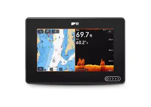
Raymarine Axiom 2 7" Chartplotter-Sonar with LHC North America and RV-100 Transducer
Model: E70721-03-102Our most popular marine chartplotters — now faster, more connected and built for the future. Axiom 2 unifies navigation, sonar, radar, video and NMEA 2000 networks into one powerful display. Choose Axiom 2 as a dedicated chartplotter for confident navigation, or step up to Axiom 2 RV for the ultimate all-in-one chartplotter and fish finder combo.
Axiom 2's LightHouse operating system is a single, simple-to-use interface for complete situational awareness. Make Axiom 2 your all-in-one multifunction display or connect additional Axiom 2 displays at your helm or a remote station.
Up to 30% faster chart rendering with a new 6-core processor and LightHouse OS. Choose Axiom 2 bundled with LightHouse Charts GEN 2 for smoother panning, faster redraws and expanded coverage.
Scan wider, see deeper and understand the bottom instantly with SideVision™, DownVision™, RealVision™ 3D, and 600W CHIRP sonar - all built in. With an all-in-one GPS chartplotter with fish finder, you can spot fish faster, view underwater structure clearly, and fish confidently from every angle.
Specifications| Physical | |
| Dimensions (Trunnion mounted) | Width: 250.4 mm (9.86 in), Height: 162.5 mm (6.4 in), Depth including cables: 218 mm (8.58 in) |
| Dimensions (Surface/Flush mounted) | Width: 201.1 mm (7.92 in), Height: 133 mm (5.24 in), Depth including cables: 218 mm (8.58 in) |
| Accessory connection | USB Micro B |
| Ethernet connection | RayNet (10 / 100 / 1000 Mbit/sec Ethernet) |
| External storage | MicroSDXC card slot x 1 |
| NMEA 2000 connection | DeviceNet (male connector built into power cable) |
| Wireless connections | Bluetooth: V4.0, Wi-Fi: 802.11/b/g/n |
| Internal storage | 64 GB |
| Transducer connection | 25 pin RealVision type connector. Requires the A80490 adaptor cable for CPT-S style transducers |
| Environmental | |
| Operating temperature | -25°C to +55°C (-13°F to 131°F) |
| Storage temperature | -30°C to +70°C (-22°F to 158°F) |
| Relative humidity | Up to 93% @ 40°C (104°F) |
| Waterproof rating | IPx6, IPx7 |
| Power | |
| Power consumption | 9.84 W |
| Operating voltage range | 8 V dc to 16 V dc |
| Fuse rating | 7 A |
| Nominal supply voltage | 12 V dc |
| LEN (NMEA 2000 Load Equivalency Number) | 1 |
| LCD | |
| Resolution | WSVGA 1024 x 600 |
| Display Brightness | 1800 nits / 1800 cd/m2 |
| Protective coating | HydroTough Oleophobic |
| LCD Type | IPS (In-Plane Switching) |
| GPS | |
| Position Accuracy | Without SBAS: <= 15 metres 95% of the time, With SBAS: <= 5 metres 95% of the time |
| Geodetic Datum | WGS-84 (alternatives can be selected on the MFD) |
| Satellite Differential Type (SBAS) | WAAS (United States), EGNOS (Europe), MSAS (Japan), GAGAN (India), QZSS (Japan) |
| Channels | Track up to 28 satellites simultaneously |
| Antenna | Internal - Ceramic chip mounted near top of unit |
| GNSS compatibility | GPS, GLONASS, Beidou |
| Almanac Update | Automatic |
| Signal Acquisition | Automatic |
| Receiver IC Sensitivity | 165 dBm (Tracking), 160 dBm (Acquisition), 148 dBm (Cold start) |
| Operating frequency | 1574 MHz to 1605 MHz |
| Refresh rate | 10 Hz (10 times per second) |
| Time to first fix from cold start | < 2 minutes |
| Sonar (RV Models) | |
| CHIRP Sonar Channels | RealVision 3D: (70 W / 350 kHz ) SideVision: (70 W / 350 kHz ) DownVision: (35 W / 350 kHz ) CHIRP High: (100 W / 200 kHz ) |
| Conventional Sonar Channels | 50/200 kHz (600 W) Note: A 600 Watt conventional sonar transducer and adapter cable is required |
| Chartplotter | |
| Waypoints | Up to 10,000 waypoints can be stored in up to 200 waypoint groups |
| Routes | Up to 250 routes can be stored, each route can contain up to 500 waypoints. The route capacity limit is subject to your chartplotter’s 10,000 waypoint limit (for example, 20 routes can be stored each containing 500 waypoints). |
| Automatic Route Planning | Yes with Navionics charts or via the Orca mobile app |
| Tracks | Up to 15 tracks can be stored, each track can contain up to 10,000 track points. |
| Compatible Charts | Raymarine LightHouse Charts Navionics C-MAP Florida Marine Tracks CMOR Mapping Standard Mapping StrikeLines Imray Digital Charts S-63 encrypted charts |
The Raymarine Axiom 2 7 Chartplotter-Sonar, part number E70721-03-102, is a marine navigation and fishfinding system designed for professional and recreational vessel operators. This unit integrates navigation, sonar, radar, and video capabilities into a single display. It is suitable for users requiring a dedicated chartplotter or an all-in-one chartplotter and fish finder solution.
The system features a 6-core processor for faster chart rendering and smoother operation, supported by the LightHouse operating system. Connectivity options include Gigabit RayNet Ethernet for networking with other sensors and displays, NMEA 2000 for engine monitoring and system integration, and Wi-Fi for route sharing with the Orca app. The included RV-100 transducer supports SideVision, DownVision, RealVision 3D, and 600W CHIRP sonar, enabling detailed underwater imaging. Its IPX6 waterproof construction and HydroTough display ensure reliable performance in various marine conditions.


This unit includes built-in SideVision, DownVision, RealVision 3D, and 600W CHIRP sonar. It comes with an RV-100 transducer to support these functions.
The system can connect with leading engines, including Mercury, Yamaha, and Suzuki, to monitor performance, fuel, and propulsion data directly from the helm via NMEA 2000.
The Axiom 2 7 features Gigabit RayNet Ethernet for faster networking between displays and sensors, and a NMEA 2000 connection for device integration. It also includes Wi-Fi and Bluetooth for wireless connectivity.
For surface/flush mounting, the dimensions are 201.1 mm (7.92 in) width, 133 mm (5.24 in) height, and 218 mm (8.58 in) depth including cables.
E70721-03-102 - Raymarine Axiom 2 7 Chartplotter-Sonar with LHC North America and RV-100 Transducer





























































