 29+Years
29+Years
29+Years
6 Available
Condition: New

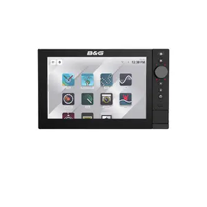
B&G Zeus SR-10 10in MFD US C-MAP No Sonar
Model: 000-16021-001C-MAP(R) X-Gen charts deliver the cutting-edge of navigation. Explore the stunning DISCOVER(R) X charts, zooming in and out in an instant. Discover new spots with incredible local detail. And explore after dark with a dedicated night mode. An upgrade to the stunning REVEAL(R) X adds incredible shaded relief and satellite imagery to your arsenal.
The X-Gen charts also unlock a host of ground-breaking features, such as the revolutionary C-MAP(R) Safety Alerts - built to automatically alert boaters to hazards up ahead, from shallow waters to buoys.
In an industry first - the X-Chart Manager lets users manage C-MAP(R) chart updates and upgrades directly from the device, with the ability to choose custom areas for a near-instant download. And there are plenty of updates, because X-Gen charts are always evolving, adding new details and features all the time.
Our latest OS has integration at its core, with seamless networking across the entire boat. Connect to HALO(R) radars for superior safety and situational awareness. Unlock next-level performance with our Triton Edge and Hercules sailing processors. And bring the very best data to the helm with our famous wind sensors, which feed into our range of Triton and Nemesis(R) instruments.
Specifications| U-Turn, C-Turn, Spiral, S-Turn, Square, Zig-zag, Depth | |
| Steering Modes | Heading Hold, No Drift, Follow-up, Non-Follow-up, Nav |
| Cartography | |
| Chart Format | C-MAP Tile (CMT) Discover X, Reveal X C-MAP Tile (CMT) Reveal X |
| Charts Supported | C-MAP DiscoverTM X, C-MAP RevealTM X. Third party charts CMOR, StikeLines (check with provider for available content) |
| Connectivity | |
| Bluetooth | Bluetooth 4.0 with support for Bluetooth Classic (currently not used) |
| Ethernet | 1 port (X-Coded M12 GbE) 1 port (yellow, 5-pin) |
| NMEA 0183 | No |
| NMEA 2000 | 1 x NMEA 2000 Micro-C port, 1 LEN |
| PC Connectivity | No |
| Video | Video In, IPCAM-1, FLIR 232/300 series. ONVIF IP Camera |
| WiFi | Wi-Fi 5 (IEEE 802.11ax) |
| Display | |
| Backlight Color | White |
| Resolution | 1280 x 800 |
| Screen Brightness | Less than 1200 nits |
| Size and Type | 10 inch SolarMax IPS Touchscreen display for wide viewing angles, extreme clarity and sunlight viewability with polarized sunglasses |
| Viewing Angles | 80 deg top/bottom, 80 deg left/right |
| Electrical | |
| Power Consumption, max. | 28 W |
| Recommended Fuse Rating | 5 A |
| Supply Voltage | 12/24 V DC (10 - 31.2 V DC min - max) |
| Humidity | IEC 60945 Damp heat 66 degC (150 degF) at 95% relative (18 hr) |
| Environment | |
| Operating Temperature Range | -15 degC to 55 degC (5 degF to 131 degF) |
| Shock and Vibration | 100,000 cycles of 20 G |
| Storage Temperature Range | -20 degC to 60 degC (-4 degF to 140 degF) |
| Waterproof rating | IPX6 and IPX7 |
| GPS | |
| Correction | 10 Hz high speed update (internal) |
| GPS Receiver Channels | 32 Channels |
| Position Accuracy | Horizontal Accuracy 3 m (9.8 ft) |
| Update rate | 10Hz |
| MFD | |
| AIS | Receive AIS data over NMEA 2000 |
| Autopilot | NAC-1, NAC-2, NAC3, NAC-D compatible |
| Cartography included | Discover X chart card of North America |
| Cartography supported | C-MAP DiscoverTM X, C-MAP RevealTM X. Third party charts CMOR, StikeLines (check with provider for available content) |
| Digital Switching | Czone / DDS |
| External Storage | 2x (microSD(R), SDHC(R)) |
| GPS | 10 Hz GNSS receiver for GPS and GLONASS, supports combinations with Galileo, Beidou, QZSS. SBAS (WAAS) |
| Radar (inc. compatibility) | Halo dome radars, Simrad Halo open array radars, 3G/4G, Simrad 10/25 kW HD Radars |
| Sonar (inc. compatibility) | No built-in Echosounder ports. Compaible with Network Sonar modules S3100, S5100, Other MFDs with echosounder ports |
| Weather | Sirius XM via WM4 module (USA only) |
| Waypoints, Routes, Tracks | 10,000 waypoints: 75,000 trackpoints: 75 saved tracks: 125 routes. Note: Zeus3, Zeus3 GH maximums will apply if on the same network |
| Compass Safe Distance - Metric, imperial | 35 cm (1.15 ft) |
| Physical | |
| Dimensions (W x H x D) | Display only: 287.9 mm x 176.1 mm x 79.6 mm (11.33 in x 6.93 in x 3.13 in) With bracket: 315.8 mm x 196.5 mm x 79.6 mm (12.43 in x 7.73 in x 3.13 in) |
| Mounting Type | Bracket mount (bracket supplied). Rear mount (brackets supplied) |
| Weight | 1.8 kg (3.97 lb) |
The B&G Zeus SR-10 10in MFD (Multi-Function Display) is designed for marine navigation, offering a dedicated interface for sailing, racing, and anchoring. This unit features a 10-inch SolarMAX IPS touchscreen display, providing clear visibility from various angles, including with polarized glasses. It integrates with C-MAP DISCOVER X and REVEAL X charts, which include C-MAP Safety Alerts for hazard warnings. The SR-10 supports full integration with HALO radars, B&G Sailing Processors, Autopilots, Triton2, and Nemesis instruments, as well as wind sensors, facilitating comprehensive boat system networking. Connectivity options include Wi-Fi 5, Gigabit Ethernet, and NMEA 2000, along with support for up to four IP video cameras. The device, part number 000-16021-001, is suitable for users requiring a robust navigation and system monitoring solution without integrated sonar capabilities.


The B&G Zeus SR-10 is compatible with C-MAP Tile (CMT) Discover X and Reveal X charts. It also supports third-party charts such as CMOR and StikeLines, though content availability should be verified with the provider.
No, the B&G Zeus SR-10 10in MFD is specified as having "No Sonar" capabilities. It focuses on navigation, system integration, and display functions.
The Zeus SR-10 offers Wi-Fi 5 (IEEE 802.11ax), Gigabit Ethernet (1 port, X-Coded M12 GbE), and NMEA 2000 (1 x Micro-C port) for seamless networking with HALO radars, B&G Sailing Processors, Autopilots, and various instruments.
Yes, the B&G Zeus SR-10 features a SolarMAX IPS touchscreen display designed for wide viewing angles, extreme clarity, and sunlight viewability, even when wearing polarized sunglasses.
000-16021-001 - B And G B&G Zeus SR-10 10in MFD US C-MAP No Sonar





























































